Top 5 AI Models for Weather Forecasting
By 2026, AI models are reshaping weather forecasting, offering faster and more accurate predictions than traditional methods. These models analyze decades of data, delivering forecasts in seconds instead of hours. Here's a quick look at the top five AI systems leading this transformation:
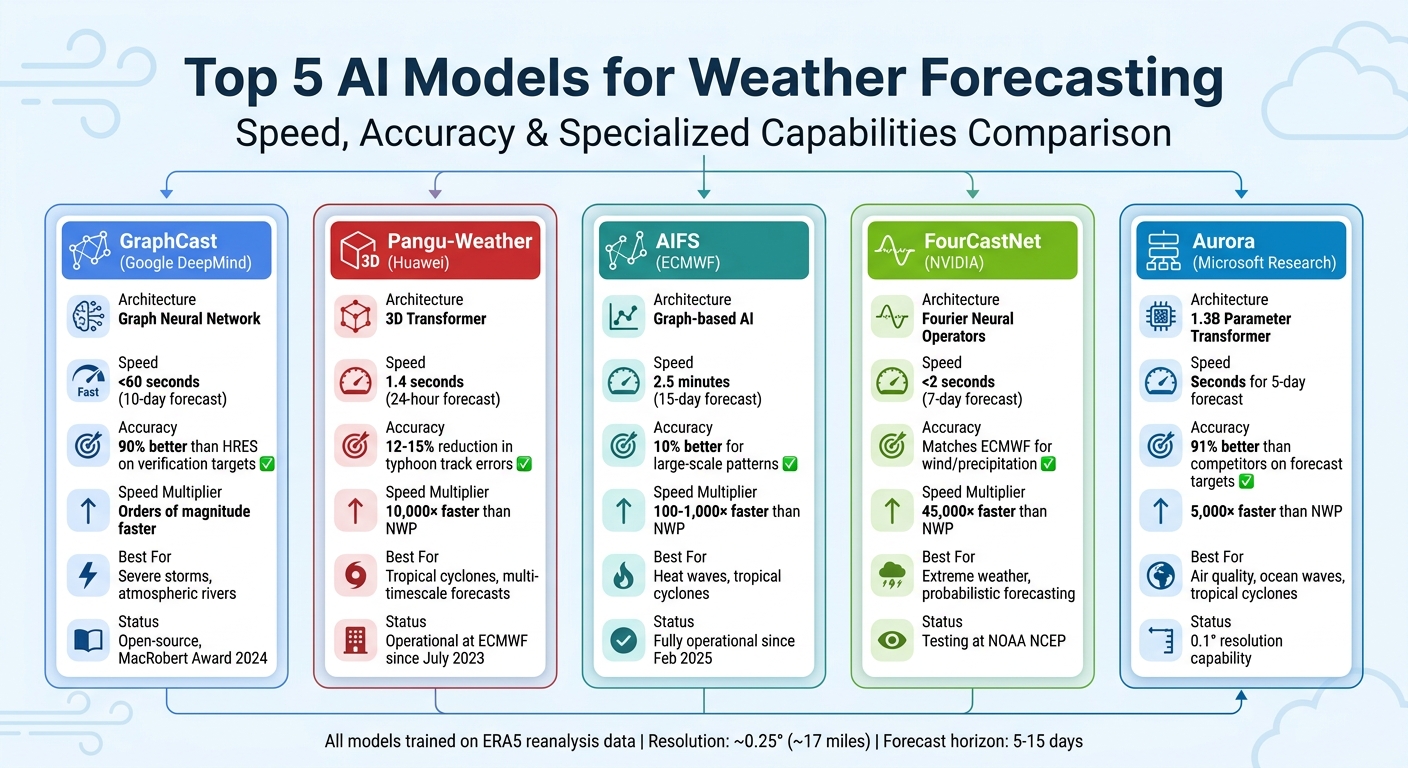
- GraphCast (Google DeepMind): Uses Graph Neural Networks to produce 10-day forecasts in under 60 seconds. It excels in predicting severe storms and atmospheric patterns with high accuracy.
- Pangu-Weather (Huawei): Employs a 3D Transformer architecture for precise multi-timescale forecasts. It is 10,000× faster than older systems and highly effective for tropical cyclone tracking.
- AIFS (ECMWF): Combines AI with graph-based methods to deliver 15-day forecasts in 2.5 minutes. Operational since 2025, it's known for improving large-scale pattern predictions.
- FourCastNet (NVIDIA): Leverages Fourier Neural Operators for ultra-fast global forecasts. It’s ideal for extreme weather events and probabilistic forecasting.
- Aurora (Microsoft Research): A high-resolution system with a 1.3 billion parameter model. It’s 5,000× faster than traditional methods and supports weather, air quality, and ocean wave predictions.
These AI models are not just faster - they’re setting new benchmarks for accuracy in medium-range forecasts, helping agencies worldwide adapt to changing weather dynamics.
Quick Comparison
| Model | Key Feature | Speed | Accuracy Highlights | Specialized Use Cases |
|---|---|---|---|---|
| GraphCast | Graph Neural Network | < 60 seconds (10-day) | Outperformed ECMWF HRES on 90% of verification targets | Severe storms, atmospheric rivers |
| Pangu | 3D Transformer Architecture | ~10,000× faster | Reduced typhoon track errors by 12–15% | Multi-timescale forecasts, cyclones |
| AIFS | Graph-based AI | 2.5 minutes (15-day) | 10% better for large-scale patterns | Operational at ECMWF, heat waves |
| FourCastNet | Fourier Neural Operators | ~45,000× faster | Matches ECMWF for wind/precipitation | Extreme weather, probabilistic models |
| Aurora | 1.3B Parameter Transformer | 5,000× faster | Leading 5-day tropical cyclone accuracy | Air quality, ocean waves, cyclones |
These advancements are making weather forecasts faster, more reliable, and accessible to more users worldwide.
AI Weather Forecasting Models Comparison: Speed, Accuracy and Features
1. GraphCast by Google DeepMind
Model Architecture
GraphCast relies on a Graph Neural Network (GNN) with three core components: an encoder that transforms grid data into a multi-scale representation, a processor that simulates dynamics through message-passing, and a decoder that converts the results back into a latitude–longitude grid. It operates on a 0.25° grid (about 17 miles square at the equator), encompassing over one million grid points. The model tracks 227 weather variables across 37 altitude levels, generates forecasts in 6-hour intervals for up to 10 days, and is trained on 40 years of ERA5 reanalysis data (1979–2018). With approximately 37 million parameters, this design enables GraphCast to deliver fast and precise forecasts.
Forecast Speed Compared to NWP
One of GraphCast's standout features is its speed. It can produce a 10-day forecast in less than 60 seconds using a single Google Cloud TPU v4. In contrast, traditional systems like ECMWF HRES require several hours for similar forecasts.
"GraphCast is orders of magnitude faster than ECMWF's operational systems, and can generate a 10-day forecast... in under 60 seconds on Cloud TPU hardware."
– Remi Lam, Lead Researcher, Google DeepMind
Accuracy for Medium-Range Forecasts
GraphCast's accuracy is equally impressive. It outperformed ECMWF HRES on 89.3% of 2,760 variables overall, achieving 99.7% accuracy for key metrics in the troposphere.
Specialized Features
GraphCast shines in forecasting extreme weather conditions. It can accurately predict tropical cyclone paths, detect atmospheric rivers, and signal record-breaking temperatures. Its open-source framework, distributed under the CC BY-NC-SA 4.0 license, has gained recognition from global agencies. It was also honored with the MacRobert Award in 2024 and named a runner-up for Science's Breakthrough of the Year in 2023.
sbb-itb-903b5f2
2. Pangu-Weather by Huawei

Model Architecture
Pangu-Weather is built around a 3D Earth-Specific Transformer (3DEST) architecture, which models the atmosphere in three dimensions. Unlike 2D models, it incorporates pressure levels as a third spatial dimension, enabling it to capture vertical atmospheric patterns more effectively. The model processes data from 13 pressure levels, tracking five upper-air and four surface variables at a resolution of 0.25° × 0.25°.
Each transformer block in Pangu-Weather uses an Earth-specific positional bias. This accounts for the absolute position on Earth and adjusts for the uneven distribution of latitude and longitude grids on a spherical surface. To reduce forecast errors over time, Huawei trained four separate models, each optimized for different lead times: 1-hour, 3-hour, 6-hour, and 24-hour forecasts. With around 256 million parameters, Pangu-Weather was trained using 39 years of ERA5 reanalysis data (1979–2017). This design improves the model's ability to extract features and significantly speeds up forecast computations.
Forecast Speed Compared to NWP
Pangu-Weather delivers a 24-hour global forecast in just 1.4 seconds using a single NVIDIA Tesla-V100 GPU. This is over 10,000 times faster than traditional Numerical Weather Prediction (NWP) systems. For comparison, traditional NWP simulations for a 10-day forecast can take hours of computation across more than 3,000 supercomputer nodes, while Pangu-Weather achieves similar results in mere seconds.
Accuracy for Medium-Range Forecasts
Pangu-Weather has set a new benchmark by becoming the first AI-based system to surpass the ECMWF Integrated Forecasting System (IFS) in accuracy. For 5-day Z500 (geopotential height) forecasts, it achieved a Root Mean Square Error (RMSE) of 296.7. In comparison, the operational IFS scored 333.7, and NVIDIA's FourCastNet had an RMSE of 462.5.
"For the first time in history, an AI-based method outperforms NWP methods in terms of accuracy." – Huawei Cloud
Specialized Features
The model is particularly adept at monitoring tropical cyclones. It tracks key variables such as Mean Sea Level Pressure, 850 hPa vorticity, 10-meter wind speed, and the 850–200 hPa thickness. In a study of 88 named tropical cyclones from 2018, Pangu-Weather demonstrated a 3-day mean direct position error of 120.29 km, far outperforming the 162.28 km error reported by ECMWF-HRES. Notably, in October 2018, it accurately predicted the landing path of Super Typhoon Yutu in the Mariana Islands 48 hours earlier than ECMWF-HRES.
As of July 2023, Pangu-Weather has been integrated into the ECMWF's operational suite, enabling users to access its 10-day global forecasts directly on the ECMWF website.
3. AIFS by ECMWF
Model Architecture
AIFS (Artificial Intelligence Forecasting System) stands out with its encoder-processor-decoder setup, which brings a fresh approach to AI weather modeling. The encoder uses a graph neural network (GNN) to project data onto a reduced-resolution grid. This data is then processed by a 16-layer Transformer-based system, which updates the forecast every six hours. Finally, a GNN decoder restores the data to its target resolution [25,27].
The system operates on native reduced Gaussian grids (N320) with an approximate resolution of 17 miles. This method cuts grid points down from 1,038,240 to 542,080, achieving global coverage while improving computational efficiency [27,28]. Built on the open-source Anemoi framework, AIFS ensures both scalability and reproducibility [25,29]. AIFS Single 1.0 also includes a "bounding" layer that enforces physical consistency by constraining variables such as precipitation, humidity, and cloud cover to realistic ranges [25,29]. These innovations align with advancements seen in other top-tier forecasting models.
Forecast Speed Compared to NWP
AIFS doesn't just innovate - it delivers results fast. It can generate a 15-day forecast in just 2.5 minutes using a single NVIDIA A100 GPU. In contrast, a traditional IFS ensemble member requires about an hour on 96 CPUs [26,27]. This efficiency leads to a roughly 1,000× reduction in energy consumption compared to conventional physics-based models. Since February 25, 2025, AIFS Single has been fully operational, running alongside the physics-based IFS to provide round-the-clock meteorological data to 35 Member and Co-operating States [29,30,31].
Accuracy for Medium-Range Forecasts
Speed is impressive, but AIFS also excels in accuracy. It extends the forecast lead time for upper-air variables by more than 12 hours. The model was pre-trained using the ERA5 reanalysis dataset (1979–2022) and fine-tuned with operational IFS analysis data (2016–2022), handling approximately 60 million quality-checked observations every six hours [25,29,30].
In January 2025, AIFS forecasted a rare snowstorm over the Gulf Coast of America four days in advance. This event, with a return period of roughly 100 years, was not part of the ERA5 training data. Yet, AIFS accurately predicted it, showcasing its ability to understand atmospheric physics rather than merely replicating historical trends.
"This milestone will transform weather science and predictions. It showcases our dedication to delivering a machine learning forecasting model that pushes the boundaries of efficiency and accuracy."
– Florence Rabier, Director-General, ECMWF
Specialized Features
AIFS's capabilities extend beyond speed and accuracy. It has proven exceptional in tropical cyclone track predictions, with performance gains of up to 20% over leading physics-based models. Additionally, it provides critical forecasts for the energy sector, such as 100-meter wind speeds and surface solar radiation, along with land surface data like soil temperature and moisture [25,29].
In April 2024, the experimental AIFS ensemble predicted a damaging cold spell near Troyes, France, 8–10 days in advance. This early warning helped mitigate frost damage to crops like fruit trees and grapevines. By July 2025, ECMWF launched AIFS ENS, a 51-member ensemble version designed to better capture uncertainty and offer a range of forecast scenarios [26,30].
4. FourCastNet by NVIDIA

Model Architecture
FourCastNet has undergone several updates to enhance its weather prediction capabilities. Initially, it used a Vision Transformer framework combined with Adaptive Fourier Neural Operator (AFNO) attention, which allowed it to grasp global atmospheric patterns in the spectral domain. By 2025, NVIDIA introduced FourCastNet 3 (FCN3), which shifted to a purely convolutional neural network. This new version was tailored for spherical geometry, incorporating local and global spherical group convolutions to better handle Earth's curvature. FCN3 operates as a hidden Markov model, relying on a stochastic latent variable to generate ensemble members that reflect the chaotic nature of the atmosphere. The model achieves global predictions at a resolution of 0.25° (~17 miles) using hybrid parallelism across over 1,000 NVIDIA H100 GPUs. This development highlights its exceptional forecasting speed.
Forecast Speed Compared to NWP
When it comes to speed, FourCastNet stands out. The original model could produce a week-long forecast in under 2 seconds. FCN3 has taken this a step further, generating a 90-day global forecast at 0.25° resolution in less than 20 seconds on a single GPU. This marks a 60× speed boost over the IFS ensemble method and an 8× improvement over top diffusion-based models.
"FourCastNet generates a week-long forecast in less than 2 seconds, orders of magnitude faster than IFS. The speed of FourCastNet enables the creation of rapid and inexpensive large-ensemble forecasts with thousands of ensemble-members for improving probabilistic forecasting."
– NVIDIA PhysicsNeMo Framework
Such speed allows meteorologists to quickly produce thousands of ensemble forecasts, significantly improving probabilistic forecasting and early warnings for extreme weather.
Accuracy for Medium-Range Forecasts
For medium-range forecasts, FourCastNet achieves accuracy comparable to the ECMWF Integrated Forecasting System for large-scale variables at shorter lead times. It even surpasses traditional physics-based models for finer details like precipitation. FCN3 maintains stability and realistic spectral patterns for up to 60-day lead times, avoiding the "blurring" issues that often plague machine learning models. A notable example came in February 2020, when NVIDIA researchers used FCN3 to predict Storm Dennis, accurately forecasting its path and wind intensities at 850 hPa five days in advance.
"FCN3 outperforms the integrated forecasting system's ensemble method (IFS-ENS), the golden standard for traditional NWP methods, and nearly matches the medium-range forecast skill of GenCast."
– Boris Bonev et al., NVIDIA Corporation
Specialized Features
FourCastNet is particularly adept at forecasting extreme weather events, such as tropical and extra-tropical cyclones and atmospheric rivers. Its ability to create large ensembles with thousands of members provides an edge in quantifying uncertainty for rare, high-impact scenarios. With its 0.25° resolution, the model captures intricate details essential for tracking precipitation and surface wind speeds during severe storms. Moreover, FourCastNet forecasts 20 key atmospheric variables, including 10-meter wind speed, total column water vapor, and geopotential heights - critical for monitoring and analyzing cyclones. Agencies like NOAA's National Centers for Environmental Prediction are already testing FourCastNet-based systems to supplement traditional medium-range global forecasts.
5. Aurora by Microsoft Research
Model Architecture
Microsoft Research has introduced Aurora, a 1.3 billion parameter model designed to revolutionize weather forecasting. Utilizing a 3D Swin Transformer alongside Perceiver-based encoders and decoders, Aurora processes a wide range of data to deliver weather predictions at varying resolutions [46,47]. The model underwent a two-phase training process: it was pre-trained on more than a million hours of diverse weather and climate simulations, followed by fine-tuning for specific tasks using Low-Rank Adaptation (LoRA) [44,45].
"Aurora's innovative architecture has been trained on over a million hours of diverse weather and climate simulations, enabling it to excel in a broad spectrum of predictive tasks while achieving an impressive spatial resolution of 0.1°."
– Microsoft Research
Aurora continues to push the limits of speed and resolution in weather forecasting, setting a new standard for AI-driven predictions.
Forecast Speed Compared to NWP
Aurora is a game-changer when it comes to speed. It generates forecasts 5,000 times faster than traditional numerical weather prediction (NWP) systems. While physics-based models often take hours to run on supercomputers, Aurora delivers results in mere seconds. This speed enables quicker scenario analysis and more timely warnings, which are critical in fast-changing weather situations.
Accuracy for Medium-Range Forecasts
Aurora's accuracy is another standout feature. It surpasses both numerical and AI models in 91% of forecasting targets. Its high-resolution setting achieves a spatial resolution of 0.1° (roughly 7 miles at the equator), while its medium-range configuration operates at 0.25° resolution. During the 2022–2023 season, Aurora became the first machine-learning model to outperform the National Hurricane Center on 5-day tropical cyclone track forecasts, outpacing seven major forecasting centers. For example, in July 2023, Aurora accurately predicted Typhoon Doksuri's landfall in the Northern Philippines four days before the event, outperforming the Joint Typhoon Warning Center.
Specialized Features
Aurora isn't just about weather - it also supports forecasts for air quality, ocean waves, and tropical cyclones. Its air quality version, operating at 0.4° resolution, predicts pollutants like PM1, PM2.5, PM10, nitrogen dioxide, and carbon monoxide. In June 2022, it successfully forecast a devastating sandstorm in Iraq a day in advance, modeling complex chemical reactions at a fraction of the cost of traditional methods [45,52].
For ocean wave predictions, Aurora's 0.25° wave version provides insights into significant wave height, mean wave direction, and wave period. In September 2022, it matched or exceeded the accuracy of leading models during Typhoon Nanmadol in Japan. Additionally, Aurora includes a dedicated tracker for monitoring and summarizing tropical cyclone paths, making it a comprehensive tool for various forecasting needs.
The AI Weather Forecasting Revolution
Model Comparison Table
These five AI models bring unique designs, speeds, and strengths to the field of weather forecasting.
GraphCast relies on Graph Neural Networks, treating the atmosphere as a network of spherical nodes. It delivers a 10-day global forecast in under 60 seconds and outperformed the ECMWF HRES model on 90% of 1,380 verification targets. Its standout ability lies in accurately predicting severe storm tracks and atmospheric rivers.
Pangu-Weather uses a 3D Earth-Specific Transformer, modeling the atmosphere as a three-dimensional volume. It operates around 10,000 times faster than traditional numerical ensemble models. The China Meteorological Administration reported a 12–15% reduction in mean typhoon track errors at 72-hour and 120-hour lead times using this model.
AIFS, developed by ECMWF, employs a graph-based architecture and is 100–1,000 times faster than conventional NWP systems. It achieved a 10% improvement in forecasting large-scale weather patterns and became the first AI model to be operational at a major forecasting agency in February 2025. Notably, during the European heat wave in June 2024, AIFS accurately predicted the event's spatial extent and intensity 7–10 days ahead, outperforming the traditional HRES model for temperature anomaly forecasts.
FourCastNet, created by NVIDIA, leverages Adaptive Fourier Neural Operators to analyze data in the frequency domain. This innovative approach allows it to run about 45,000 times faster than traditional NWP systems while maintaining ECMWF's accuracy for wind and precipitation forecasts.
The table below summarizes the architecture, speed, accuracy, and specialized capabilities of these models.
| Model | Architecture Type | Processing Speed | Accuracy Metric | Special Capabilities |
|---|---|---|---|---|
| GraphCast | Graph Neural Network (GNN) | Under 60 seconds for 10-day forecast | Outperformed HRES on 90% of 1,380 targets | Superior tracking of severe storms and atmospheric rivers |
| Pangu-Weather | 3D Earth-Specific Transformer | ~10,000× faster than NWP | Matched or beat HRES on 73% of metrics | Multi-timescale design for 1-, 3-, 6-, and 24-hour forecasts |
| AIFS | Graph-based | 100–1,000× faster than NWP | 10% better accuracy for large-scale patterns | First AI model operational at a major agency (ECMWF) |
| FourCastNet | Fourier Neural Operator | ~45,000× faster than NWP | Matches ECMWF skill for wind and precipitation | Learns in frequency space for efficient global pattern capture |
| Aurora | Foundation Transformer | 5,000× faster than NWP | Leading 5-day RMSE | Integrated weather, air quality, and climate projections |
This table underscores how AI is transforming the speed, precision, and scope of weather forecasting.
Conclusion
AI technologies are transforming weather forecasting in ways that were unimaginable just a few years ago. Tasks that once required hours of processing on supercomputers can now be completed in under a minute using a single GPU. By shifting from solving intricate physics equations to recognizing patterns in decades of historical data, forecasting has become faster, more affordable, and widely available to agencies worldwide. These advancements are reshaping how we approach emergency preparedness and operational planning.
In October 2025, the National Hurricane Center successfully employed a Google DeepMind AI ensemble to forecast Hurricane Melissa's rapid intensification from a Category 1 to a Category 5 storm three days before it hit Jamaica - an unprecedented achievement in hurricane prediction. Later that year, NOAA introduced the Hybrid Global Ensemble Forecast System (HGEFS), combining 31 physics-based models with 31 AI-driven models to better address forecast uncertainties.
"These AI models reflect a new paradigm for NOAA in providing improved accuracy for large-scale weather and tropical tracks, and faster delivery of forecast products to meteorologists and the public at a lower cost through drastically reduced computational expenses." – Neil Jacobs, Ph.D., NOAA Administrator
AI's impact extends beyond hurricanes. It powers real-time precipitation predictions for the next 0–6 hours, crucial for urban flood warnings and ensuring safety at specific sites. In the energy sector, AI bias-correction tools enhance wind power forecasts. Meanwhile, apps like Windy (premium at $20/year) and Tomorrow.io (premium at $5/month) bring these advanced forecasts directly to the public.
FAQs
How do AI weather models stay physically realistic?
AI weather models achieve a strong connection to physical reality by incorporating fundamental physical principles and constraints into their frameworks. These models are excellent at forecasting large-scale weather patterns, but they still face hurdles when it comes to accurately representing finer details, such as the wind fields within tropical cyclones. Innovations like the WSINDy algorithm, along with the integration of physics-based constraints, enhance the clarity of these models and ensure their predictions remain consistent with established physical laws. This approach strikes a balance between data-driven methods and the core dynamics of weather systems.
Which model is best for hurricane and tropical cyclone tracking?
AI models with a track record of accurate storm path predictions are particularly well-suited for monitoring hurricanes and cyclones. Research from Rice University showcases models that perform exceptionally well in forecasting cyclone trajectories and pinpointing landfall locations. Similarly, NOAA leverages cutting-edge AI-powered global weather models to enhance both the speed and precision of storm predictions, making them powerful tools for tracking severe weather events.
Are AI forecasts used in official U.S. weather warnings yet?
The National Oceanic and Atmospheric Administration (NOAA) has officially incorporated AI-driven global weather prediction models into its forecasting process. These cutting-edge tools improve the speed, accuracy, and efficiency of weather predictions. As a result, the public now benefits from more reliable and timely weather warnings, enhancing preparedness for severe weather events.